Administrative area boundary measurement
Land boundary survey (land boundary survey) is a survey of administrative areas and parcel boundaries, boundary points, important landmark facilities, etc.
The purpose of administrative area boundary surveying and mapping is to confirm and determine a fair and reasonable administrative area boundary by analyzing and confirming the information and location of the administrative area boundary, so as to provide basic data and scientific basis for all levels of government border management.
Administrative area boundary surveying and mapping content: preparation of boundary surveying and mapping, boundary pile embedding and determination, boundary point determination, boundary line and related topographic element surveying and mapping, production and printing of boundary agreement, boundary point location and boundary line description.
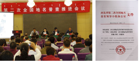
The second national census of geographical names
The purpose of the census of geographical names is to ascertain the basic situation of geographical names, to master the basic data of geographical names, to improve the standardization of geographical names, to strengthen the construction of geographical information services, and to provide comprehensive and accurate geographical names information for the society.

The Promotion Meeting of the Second National Census of Geographical Names

Geographical name survey
-
 REAL ESTATE DEVELOPMENTReal estate development stage, pre-approval report construction stage, engineering construction stage, completion acceptance stage.
 -
 NATURAL DISASTER SURVEYOur company adopts multi-disciplinary, multi professional fusion technology (including mobile measurement system and unmanned aerial vehicle ...
 -
 AGRICULTUREThe contracted management right of rural land ownership registration certification To obtain, from the low altitude unmanned aerial vehicle i...

